ITS
Datum
|
Most of this page
is more than a year old. Resolution has been achieved on many of
the "outstanding dilemmas" below. Watch for an update soon.
The section on Rubberstreeting (end) has been added recently.
|
The ITS Datum, proposed
by Oak Ridge National Laboratory (ORNL), is a planned network of monuments
across the United States, that could potentially serve as
-
a positional reference for ITS
applications corresponding points in commercial databases are identified,
and rubbersheeted on the fly to the more accurate Datum coordinates;
-
a uniquely identified set of
reference markers (nodes and links), relative to which locations may be
expressed, and distances measured.
In the long term a Datum may
evolve into an accurate standard nationwide street network. Commercial
vendors would add value by attaching attributes and application software,
such as navigation, traffic management and address geocoding.
A prototype Datum has already
been developed, based on the National Highway Planning Network (NHPN) database.
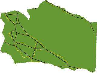
It consists of about 50,000 points across the country. The illustration
at right shows the county of Santa Barbara, the NHPN in gold, and the prototype
Datum in black. Points
in this prototype are defined to +/- 80 metres. Clearly this is not
sufficient for many applications. The network will have to be densified
before it can serve a useful purpose in ITS. Prior to an expensive
national scale densification effort, questions need to be answered on
-
point selection
-
database structure
-
associated information items
-
administrative and maintenance
mechanism
If a national infrastructure
such as this could serve similar needs in application areas other than
ITS (e.g. GIS-T), then those user requirements should be considered in
the design process.
To Be Resolved
It is clear that the Datum is
a necessity, to improve the accuracy of location messaging. We have
documented gross disagreements between street network databases (example),
and tests of the Cross Streets Profile show that messaging standardization
alone is not sufficient for unambiguous communication. Future changes,
whether geoid standards or tectonic movements, demand a flexible referencing
structure. The concept and methods pertaining to the ITS Datum are
relatively well understood. What is yet unclear is the performance
requirement: what level of accuracy it is required to achieve, and at
what cost. Consultations with user groups are underway to gain
a better understanding of this.
Point density is one
of the principal determinants of cost. Should Datum points be located
at major highway intersections only, every major street intersection, every
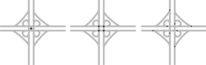
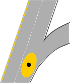
residential street intersection, every driveway? The figure below
shows three different ways of capturing a freeway intersection. The
first employed in the 50,000 point national prototype uses one point
to represent the entire interchange; the second considers the intersections
of carriageways; the third looks at each decision point (based on drive-on-the-right;
British readers consider the other 8 points in the intersection).
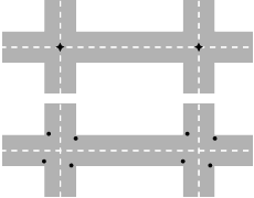
Similarly there are different
ways of capturing city streets. One model considers the intersection
of centerlines; the other surveys a point on each incident link, e.g. at
the STOP line in the right hand lane. Note that the first can be
derived from the second in most cases.
 On the matter of resolution
and accuracy, some argue for an engineering-grade survey of Datum points,
i.e. correct to a few centimetres. An obvious difficulty is that
centrelines and kerblines are themselves nebulous targets, that wander
with each re-lining and re-surfacing of a street. Does a Datum point
then require a physical stake and brass marker in the ground? An
associated question is how the point is to be surveyed by kinematic GPS
using a van traveling at highway speed, or a static survey. The costs
differ significantly.
On the matter of resolution
and accuracy, some argue for an engineering-grade survey of Datum points,
i.e. correct to a few centimetres. An obvious difficulty is that
centrelines and kerblines are themselves nebulous targets, that wander
with each re-lining and re-surfacing of a street. Does a Datum point
then require a physical stake and brass marker in the ground? An
associated question is how the point is to be surveyed by kinematic GPS
using a van traveling at highway speed, or a static survey. The costs
differ significantly.
Then there are placement
rules. A standard would require that each authority charged with
establishing the Datum must use a prescribed procedure for determining
appropriate points. Exactly where does one place a point at a freeway
exit? Some suggestions:
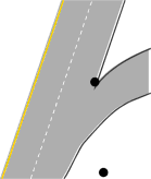
-
Gore points, where the
white lane markings form a V (as the figure illustrates, that point isn't
exactly cast in stone; surveying it to engineering accuracy would be pointless)
-
Off-road points, say
2 metres to the right of the pavement (to facilitate static survey; hopefully
a different strategy would be used on embankments).
-
Decision point, where
a driver acts on a decision to turn. If a decision point is surveyed
from a vehicle traveling at highway speed an inexpensive form of survey
there is an inherent uncertainty in fixing it, due to (a) uncertainty
in where the decision point really is, (b) human reflex error in point
capture, (c) GPS error. This could be 510 metres.
 |
 |
 |
|
Gore point and off-road
point
|
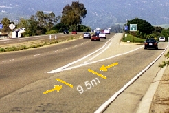
Gore point wandering:
this one moved 9.5 metres when the right shoulder line was repainted 0.6
metres left of its earlier position
|
Decision point showing
zone of uncertainty
|
Incremental
Development?
Clearly there is uncertainty
in all of the above approaches, due to (a) determining the point to be
fixed, (b) method of survey, (c) variability in the location of the point
over time. It seems inevitable that at least in the short term, a
Datum point can be fixed to no better than 510 metres on freeways, and
13 metres on urban streets.
A longer term approach is
to plan incrementally. Consider the 50,000 point Datum, already created,
as Phase I. In Phase II (say to the year 2005):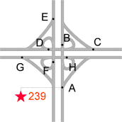
-
decision points are surveyed
by kinematic GPS, to say 5 metres;
-
highway ramps are aggregated
into clusters and labeled (illustration at right);
-
driving distances are measured
between Datum points, correct to 10 metres, using Distance Measuring Instruments
(DMIs).
Phase III kicks in when it is
deemed necessary and practical to improve accuracy to less than a metre.
A brass marker may be established for each cluster (the red star in the
illustration, not necessarily in a paved area) and local Datum points surveyed
relative to it, with whatever precision is appropriate. Futuristic
technologies, e.g. beacons triggered by vehicle sensors/identifiers, may
transmit accurate and current data on the intersection or neighbourhood,
to passing vehicles.
Database
Structure
We have used the terms "nodes"
and "links" above in reference to the ITS Datum. This terminology
has caused some confusion in the past, because some readers think it implies
that every node and link in the physical street network has to be re-surveyed
to great precision. It should be obvious from the discussion above
that this is not the case.
There is no immediate need
for the Datum to be a topologically structured network (this would
be a longer term requirement if the Datum were to evolve into a skeletal
national street network). As new points and lower-level objects are
inserted, topological enforcement would require reassignment of IDs.
We are examining ways to preserve topological integrity while not discarding
IDs. Further details in the proceedings of the technical
issues breakout group from the first workshop on public sector user
requirements.
Rubberstreeting
January 1999. VITAL
has developed an algorithm for geometric adjustment of discrete topological
fields (i.e. street networks) that can be applied to correcting maps in
real time using the ITS Datum.
Larger
image
|
Residential neighborhood
example
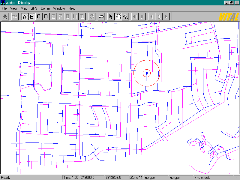
Before adjustment:
two maps show positional discrepancies up to 100m. A vehicle driving down
the blue centerline (the true alignment of the road) appears to be in someone's
backyard relative to the pink centerline (from vendor E). |
Larger
image
|
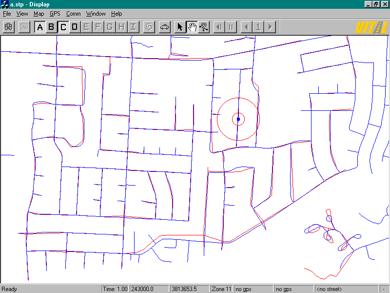
After E is rubber-streeted:
the maps are almost in complete agreement, and the vehicle is correctly
positioned on both the pink and blue centerlines. |
Larger
image
|
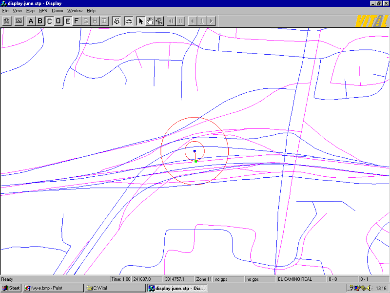
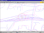
Freeway interchange example
Before adjustment:
a westbound vehicle (blue dot in the center of the red circles) exits to
the southbound ramp, as can be seen in the blue database, but with respect
to the pink centerline, it appears to be still on its original course in
the westbound lane (green dot). |
Larger image
(coming soon)
|
After E is rubber-streeted
... the problem is not entirely solved, in fact parts of
the interchange are transmogrified. The problem is that database
E misrepresents not just the geometric alignment but also the topological
relationships in the interchange. The Datum has to be designed to
overcome this, by means of a subsystem of topological specification and
ramp identification, in addition to just authoritative coordinates. |
Finally
...
The ITS Datum promises solutions
in ITS, but many questions remain unanswered with regard to its design
and deployment. We are in the process of consulting public sector
users to gauge the performance requirements of the Datum. Further
details under Meetings.
Last update 1999-04-15
Research
Home Page