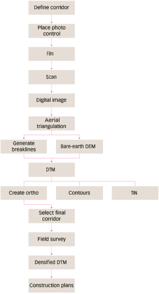
Figure 1. Can-do photogrammetry process. Total production time: 24 mo. Total cost $500K. Area: 25 sq mi.
|
|
| Click thumbnail to enlarge. Figure 1. Can-do photogrammetry process. Total production time: 24 mo. Total cost $500K. Area: 25 sq mi. |
To reduce the time required to plan and design highway projects, highway
agencies have begun to streamline processes. In order to meet the extensive
data requirements for environmental assessment and final design, some agencies
have chosen to collect and process more terrain data and imagery products
than they will ultimately need, in order to be able to rapidly respond to
changing location decisions. While facilitating a smoother, faster
planning process, the additional data collection and processing is expensive
and time consuming. For example, a highway bypass study may require
as much as $500,000 and 18 months of photogrammetric processing (see Figure
1).
|
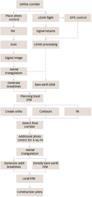
| Click thumbnail to enlarge. Figure 2. LIDAR method. Total Production time: 6 mos. Total cost: $200K. Area: 25 sq mi. |
The existing process requires early collection and processing of data to support final design. However, only the final design stages of project development may require the accuracies provided by conventional photogrammetric processing. The Iowa DOT proposed that advanced methods of surface mapping (LIDAR) and digital photography may be used for preliminary planning and location issues, limiting expensive and time consuming photogrammetric work to the final alignment corridor. Further, inherent inflexibilities of aerial photography (leaf-off, high sun angle conditions) required spring flying, was not always convenient for project task sequencing.
|
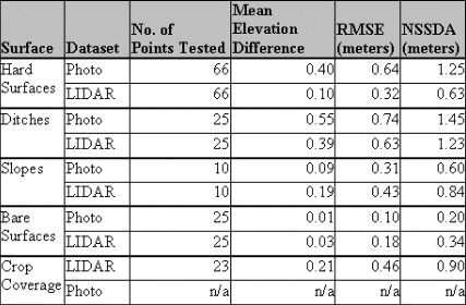
| Table 1 |
If LIDAR developed terrain products and digital imagery were sufficient for planning stages, products could be delivered to planners and designers faster at lower costs. Once final alignment decisions were made, photogrammetric control and processing could be limited to an area perhaps one fifth or smaller than the original location corridor. This scale of photogrammetric work could be completed in short time at much reduced cost. Figure 2 shows a representation of the LIDAR enabled process.
Early estimates indicate a possible savings of 7 months and $250,000.
In order for these savings to be realized, engineers and planners must be
able to use the products and resulting designs must be of sufficient accuracy.
The project considered two principal aspects:
|
|
| Figure 3 |